Corridor Studies
Ensure corridors serve existing and future travel demand
Access on-demand, high-fidelity mobility data to evaluate existing corridor conditions, anticipate future usage, prioritize improvements, and communicate investments to the public and stakeholders.
Accelerate corridor improvements with multi-year mobility trends, available in minutes
Add precision to all corridor planning phases with granular traffic data.
Easily run multiple corridor analyses for a complete traffic picture with validated data.
Compare recent and historical data to measure corridor performance across multiple years.
Justify prioritization decisions with easy-to-digest dashboard reports.
Fill your data gaps for any and all corridors
Get started
After 25 years delay, big data enables a critical 40-Mile corridor study
Read success storyRoute 28 is a critical corridor for Pittsburgh-bound commuters, freight operators, local residents, and visitors to nearby trails and parks.
After 25 years without a comprehensive study, Southwestern Pennsylvania Commission (SPC) partnered with other agencies to get the full picture of existing conditions on Route 28.
Planners were able to quickly run multiple analyses to measure current travel behaviors, including traffic by trip duration and trip speed.
By leveraging StreetLight’s on-demand metrics for the entire 40-mile corridor, the agency avoided the need for costly and time-consuming traffic counter installs, allowing them to stretch their budget and shorten their timeline.


StreetLight Corridor Studies: At a glance
Get started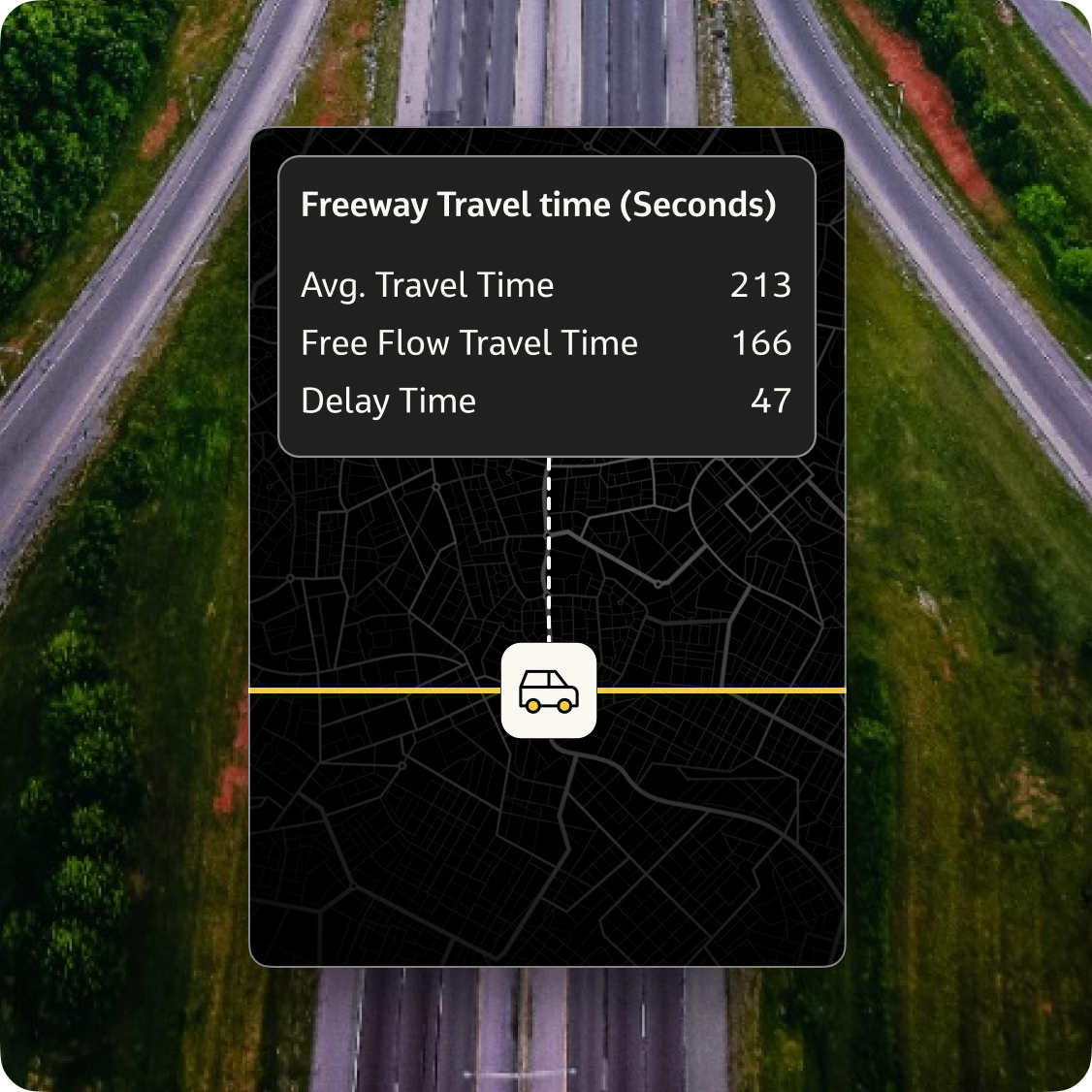
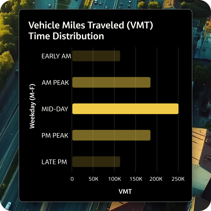
Get mobility metrics, including VMT, delay hours, travel time to plan for all corridor planning phases.
Access automated and validated traffic counts and speeds (spot and segment speeds, 85th percentiles) to understand corridor flow.
Understand where traffic is coming from and going to for effective traffic planning measures.
Measure mobility conditions across years with recent and historical data.
Scan and compare corridor segments to get a macro view of your region.
Access 3D maps and metrics by day parts, day types, and peak hours.
Check out other StreetLight products
Access our full suite of tools and visualizations to solve all your most pressing transportation planning challenges.
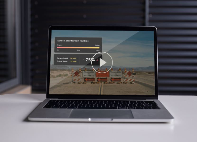
Solve bottlenecks with quick access to multi-year traffic insights for all your roads in one easy-to-use platform.
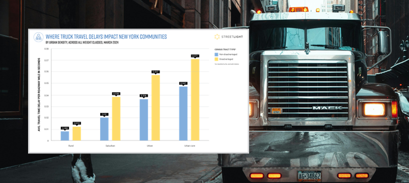
Accelerate your freight planning decisions with the industry’s most robust truck
activity data, available in minutes.

Streamline your region’s traffic flow with recent every-intersection turning movement counts.

Pinpoint the most high-risk locations across your entire multimodal network.
Resources
Explore our library
Case studies, data-driven research, and timely articles to learn how StreetLight helps solve corridor planning challenges.


Our Customers
See why they chose StreetLight
FAQs
Quick answers to questions you may have
Discover everything about StreetLight’s corridor studies product features, benefits, and more.
A corridor study is a planning project that aims to characterize existing and future roadway conditions along a major connective roadway (i.e., corridors) used by vehicles, bicycles, transit, and pedestrians. The scope of a corridor study may be hyper-local (a few miles or less) or it may account for dozens of miles of roadway, as is often the case when studying a major interstate. You can read more about Corridor Studies on our blog here.
StreetLight’s Corridor Studies Solution delivers the most commonly used metrics for corridor analysis, including volumes, VMT, TMC, vehicle speeds, delay hours, and more. This can save agencies months on manual data collection and costly sensor installs. Exportable data visualizations also assist in the creation of corridor plan documents and help earn buy-in from public and political stakeholders.
StreetLight’s data is collected from connected vehicles and the Internet of Things, rigorously anonymized and validated, and processed by our proprietary Route Science® algorithm to transform trillions of data points into the mobility metrics transportation professionals use every day, such as traffic volumes, speeds, and travel times. Unlike traditional data collection methods like roadway sensors, manual counts, and surveys, this big data approach can deliver metrics for any road and any time period, without the limitations of traditional methods like costly sensor installs, small sample sizes, human bias, or putting agency staff at risk.
The Corridor Studies solution provides both spatial and temporal granularity. Users will get hourly, daily, monthly, and yearly temporal granularity. Spatial granularity varies with the ability to analyze roadways at segment and spot-level. A StreetLight rep can help you determine the granularity level to help accomplish your specific goals.
Within the Corridor Studies solution, you can easily access both historical and the latest month of data to analyze year-over-year or monthly trends. A StreetLight rep can help you determine what data periods are currently available to help accomplish your goals.
Do you need data to inform your next project?
Talk to StreetLight about your needs, and join us in shaping a more efficient, sustainable world.
Here are some resources to help you go a step further.