7 Key Features of Transportation Analytics Software
For today’s transportation planners, the need for specialized, in-depth data is a given. Planning departments rely on a plethora of important metrics to evaluate traffic patterns and choose the best possible infrastructure upgrades.
Yet access to such data and analytics comes in many forms. Many transportation analytics providers offer Big Data solutions, but not all of these options are created equal. With a variety of choices, how can planners ensure they select the right transportation software for their needs?
The best tools have seven essential features for transportation data analytics, each working together to provide a complete source of transportation insights. We’ll explore each of the following features in turn:
- The power of Big Data
- Machine-learning algorithms
- A wide variety of metrics
- Detailed mobility insights
- Built for transportation studies
- User-friendly formats
- Privacy protection
1. The Power of Big Data
While traditional data from surveys and sensors still has a place in modern transportation planning, the depth of insight that Big Data can provide is an indispensable addition. With broader coverage and large datasets that support enhanced granularity, big data helps planners keep up with fast-changing traffic patterns and region-wide trends that traditional methods typically struggle to capture.
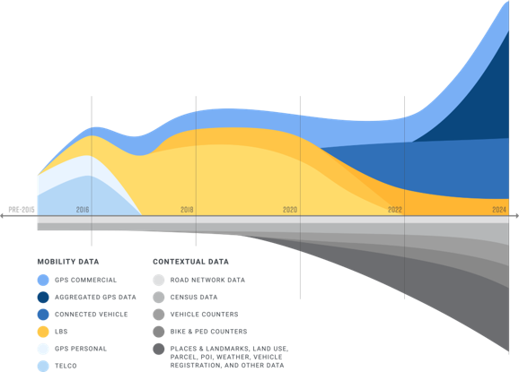
Instead of relying solely on limited data collection methods, the best transportation analytics tools draw extensive data from a wide range of sources, such as GPS systems, commercial fleets, census results, Connected Vehicle Data, and more. The larger the sample size, the more accurate and helpful the information it provides.
Additionally, the most informative Big Data in transportation details more than just vehicle traffic patterns. It covers multimodal transportation, pulling in essential numbers from public transportation, bike and pedestrian movement, ride-sharing networks, and more.
As the industry leader in traffic data analysis, StreetLight offers more than a decade of validated mobility data compiled from trillions of data points. The StreetLight InSight® platform includes exhaustively tested recent and historical insights, and it’s constantly adding new data sources as they emerge.
2. Machine-Learning Algorithms
Simply having access to a massive amount of data isn’t enough; the task of extracting and organizing, not to mention analyzing and evaluating these massive data sets, is far beyond the scope of most transportation departments. Machine learning — a fundamental component of artificial intelligence (AI) — accelerates this process and (when used properly) provides more accurate results.
With so many transportation analytics now available, only machine learning can bridge the gap between data and analysis. It enables comprehensive analysis of trips from the moment journeys begin to the moment they end, via any mode, on all roads and paths. By being continually trained with vast amounts of data, these algorithms can more accurately pinpoint the correct data and quickly analyze it.
StreetLight accomplishes this through its Route Science® machine learning algorithm, which transforms trillions of inputs into contextualized, aggregated, and normalized travel patterns. Core StreetLight metrics have been exhaustively validated against external sources, including permanent and temporary sensors, household surveys, and the Census, proving that machine learning can efficiently and effectively capture massive amounts of invaluable traffic data.
3. A Wide Variety of Metrics
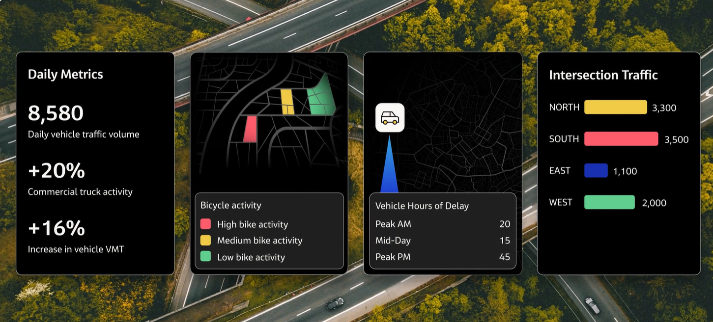
The most useful transportation planning software offers a wide range of metrics for thorough and detailed analysis. That involves much more than vehicle traffic count metrics like Annual Average Daily Traffic (AADT) and Turning Movement Counts (TMC), as vital as those metrics are for planners. Other critical data points include:
- Origin-Destination (O-D) patterns, to help understand trip purpose, top routes, and source of travel demand
- Vehicle Miles Traveled (VMT), to measure emissions, travel demand, and more
- Vehicle Hours of Delay (VHD), to quantify the extent and impact of congestion
- Vehicle Speed, to evaluate safety concerns and congestion impacts
- Bike and Pedestrian Volumes, to understand where Vulnerable Road Users face the greatest safety risks and identify opportunities to encourage active transportation modes over vehicle travel
These are just a few examples of the types of metrics that drive informed decision-making. The best software solutions offer an array of validated metrics for commute planning, safety analyses, intersection studies, and more.
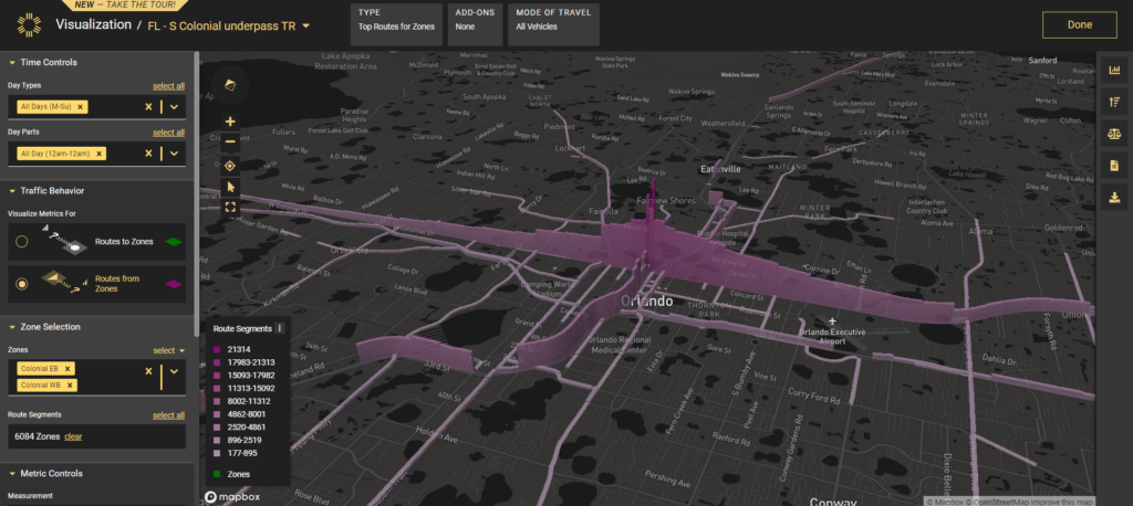
A Top Routes analysis in StreetLight InSight® highlights where drivers tend to go after they leave a particular location (in this case, an underpass along Colonial Drive in Orlando, FL).
4. Detailed Mobility Insights
The greater the breadth and scope of data at planners’ fingertips, the more insights they have access to. But perhaps even more important for deeper analysis and understanding is the level of granularity in the numbers — and the interplay between those various data points.
In other words, planners frequently need more than a regional or high-level overview of traffic patterns. They must see mobility numbers for precise time periods and specific road segments. And they must understand how metrics like VHD and TMC relate to driving patterns and decisions.
To provide this level of precision, StreetLight delivers data for any road, any mode, and any time period. Transportation activity can be broken down into 15-minute bins, and multiple metrics can be overlayed for deeper insights. This empowers more informed, impactful decisions. As planners zero in on precise times and locations where issues occur, they can better anticipate the impact of potential changes, weigh the pros and cons of project proposals, and monitor roadway conditions that are developing, even in real time, as the demo below explores.
5. Built for Transportation Studies
The primary goal of using Big Data in transportation is, of course, to support better transportation studies and enable data-driven decisions. Rather than merely producing a complicated data library, transportation software should offer purpose-built analytics catered to the types of projects planners routinely encounter, from safety studies to corridor planning. Whichever transportation analytics software you consider, the test is the same: Does their data simplify the process of studying traffic patterns and evaluating proposed changes?
For instance, StreetLight InSight® data offers purpose-built solutions for safety studies, congestion management, emissions measurement and climate resiliency planning, transportation modeling, and more. This helps agencies access the data they need, organized and visualized in ways that help them quickly translate numerical outputs into actionable insights like where to put a new bike lane or when to schedule repairs on a major highway.
For example, in the video below, a Senior Regional Planner for the Southern California Association of Governments (SCAG) explains how his team uses StreetLight’s Safety Prioritize tool to prioritize the most urgent road improvements and evaluate the impact of their projects.
6. User-Friendly Formats
Yet another trademark of the best transportation analytics software is its ability to translate and repurpose data for use in a myriad of different formats. It should be easy for users to move from a graphical overview with city-wide data summaries to a CSV with tabulated data for detailed reports.
When analytics are quickly convertible, it’s that much easier to leverage traffic data for the next important project and share information with stakeholders. Grant proposals, for instance, rely on clear, powerful data presentations to secure funding and project buy-in. Tools like StreetLight InSight® allow planners to toggle between 3D visualizations, Esri ArcGIS maps, spreadsheets, and more in order to make the most compelling case possible for their traffic solutions.
7. Privacy Protection
Privacy is a growing concern in the expanding world of Big Data. As companies collect more information, consumers and citizens are increasingly worried about just what info they have and how they’ll use it. Transportation planners and other stakeholders in this arena should be eager to show that their decisions are data-driven without being powered by privacy violations.
That makes extensive privacy protections a critical feature of any transportation analytics software you consider. The data collected and provided by these companies must be based on composite groups of people and aggregate traffic patterns — never on specific individuals. It goes without saying that transportation data analytics companies should not receive or use personally identifiable information, but instead employ multi-layered technical safeguards to prevent any exposure of personal information.
As a leader in transportation analytics, StreetLight takes its commitment to privacy very seriously. The data available in the StreetLight InSight® platform is aggregated and anonymized so that individuals can’t be identified. You can learn more about StreetLight’s data privacy principles here.
Your Hub for Big Transportation Data
Accurate, detailed, and informative data is integral to meeting today’s transportation challenges — and building a more effective, sustainable transportation infrastructure for tomorrow. Whether you’re conducting a high-level transportation network analysis for your region or digging into the metrics for one problematic corridor, you need numbers that empower intelligent, strategic planning.
Fortunately, you can find these insights and more in one easy-to-use platform. StreetLight InSight® is built on Big Data and advanced machine learning algorithms to provide the most robust, comprehensive set of mobility insights available to transportation planners today. With this set of tools, you can access the analytics you need for effective planning and decision-making.
StreetLight draws together data from a vast array of sources, including census results, GPS data, location-based services, road and vehicle sensors, and Connected Vehicle Data. More importantly, it presents information in easily digestible formats planners can use for project planning, grant writing, and in-depth analysis. With access to this much information, you can be confident in each study you conduct or project you plan.
Ready to explore for yourself? Get started with StreetLight today.