Connected Car Data Creates Road Safety Insights
There were more fatal vehicle crashes in 2020 compared to 2019, according to the National Safety Council, all while the amount of driving as measured by Vehicle Miles Travelled (VMT) declined. This seems counterintuitive. If we want to reduce these fatal crashes, we must improve the way we measure and plan for safety. As we discussed in our Pedestrian Safety eBook, simply looking at a total number of crashes without taking other information into account could distort our understanding of the real safety risks to transportation system users in a particular area.
When StreetLight presented at the AASHTO GIS-T conference last month, we discussed the significant value that can be unlocked by blending transportation metrics with non-StreetLight datasets. Here we share an example from our safety solutions partner, Ford Mobility.
Factoring in “Harsh Events”
Ford Safety Insights, Ford Mobility’s web-based safety tool, offers connected vehicle data on various “near miss” indicators such as harsh braking, harsh acceleration, and hard cornering. We worked with Ford Mobility to compile the number of harsh events at the county level. Using StreetLight’s VMT Monitor Metric, we can calculate the number of harsh events per million VMT and analyze which counties in the U.S. have the highest ratios.
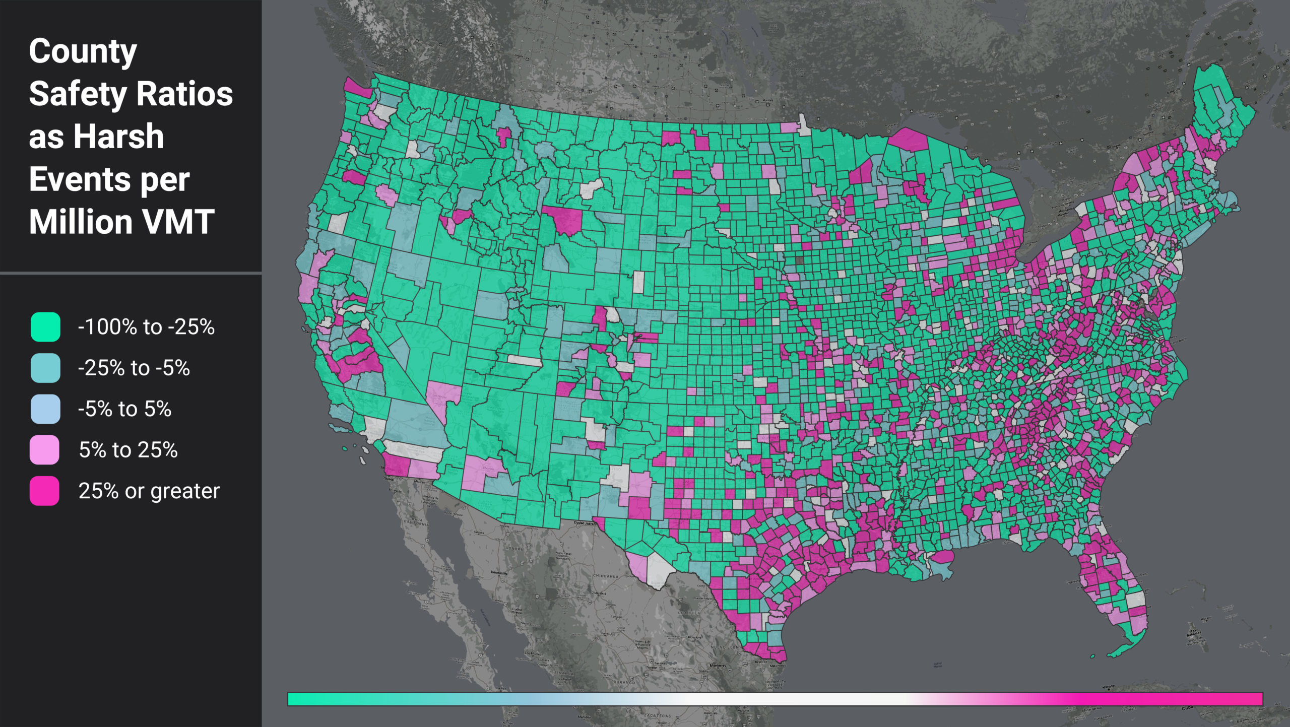
If one area has more harsh events just because they have more driving, that doesn’t really tell us much. But if an area has a lot of harsh events per mile travelled, then for any driver in that area, each mile driven is more dangerous than average. Figure 1 shows a heatmap of counties by their harsh events per million VMT (HE per VMT) ratio.
We compare each county’s HE per VMT to the nationwide average (29.36). The counties in teal color have a lower HE per VMT than the US average, and those that are magenta have higher.
Figure 1: National heatmap of U.S. counties as measured by a ratio of harsh events (HE) per million VMT.
When we filter for the counties with higher-than-average HE per VMT, we see that certain regional patterns emerge. In Figure 1, areas around the Gulf Coast, the Appalachian region, and coastal/border counties light up. This pattern suggests further analysis into local factors such as topography, road curvature, percentage truck and pedestrian activity, and more to help us understand why these counties have such high HE per VMT ratios.
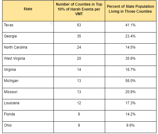
We also see that the top counties are confined to certain states. In fact, 13 states do not have a single county in the top 10%. For states with counties in the top 10%, some show up far more often than others. For example, 58% of Michigan’s population lives in counties with high rates of harsh braking events, while only 10% of Ohio’s population lives in similar high-risk counties.
Table 1: Top Counties by HE per VMT and Population Distributions
Calculating Population’s Effect
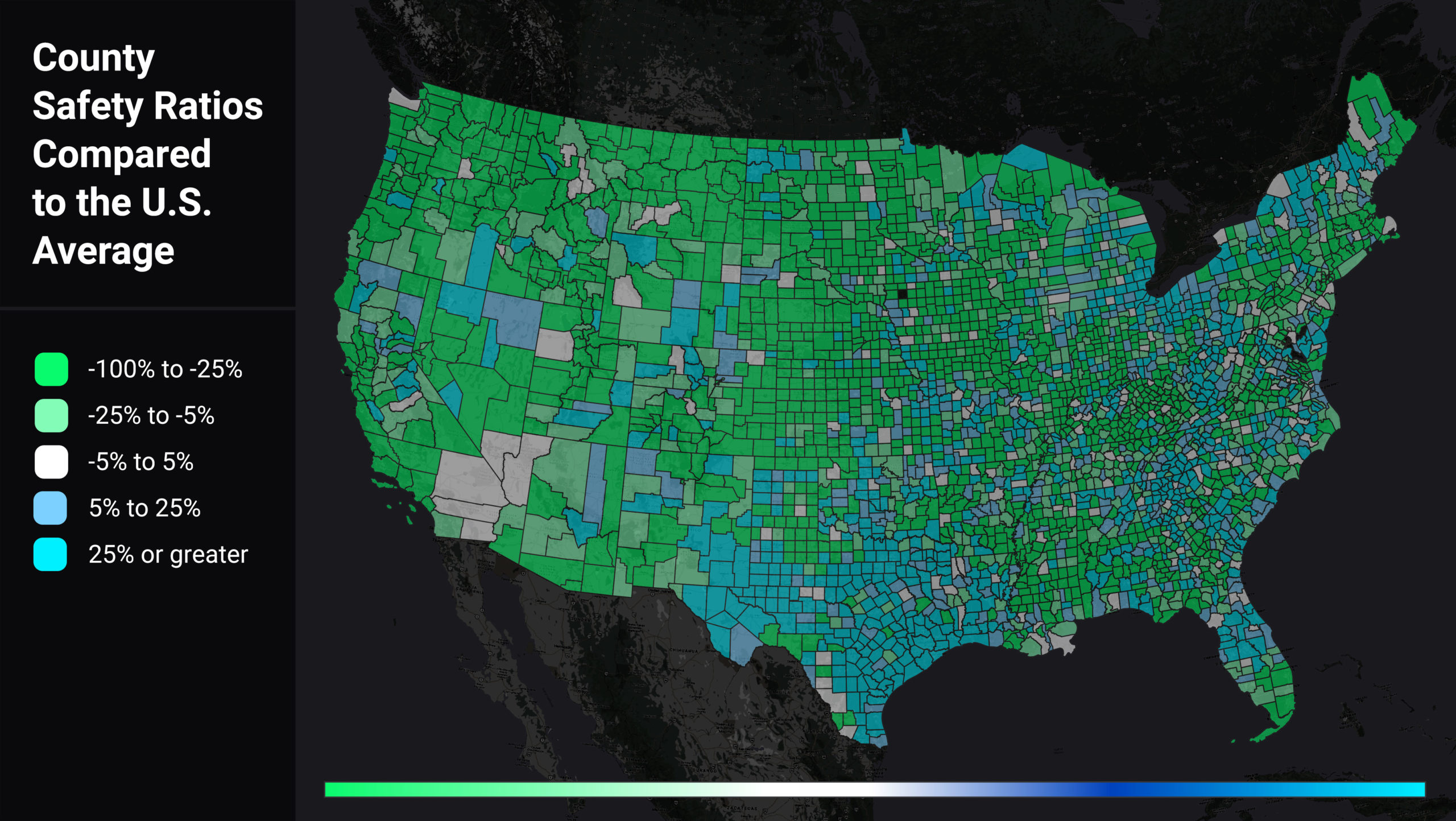
We wanted to assess if population was the real driver of a county’s higher-than-average HE per VMT, so we also analyzed harsh events per capita (HE per capita). We looked at each county’s HE per capita relative to the U.S. average (0.3), illustrated in Figure 2. Counties in green have lower than average HE per capita, while counties in blue have higher than average HE per capita.
Figure 2: Heatmap of U.S. counties by harsh event (HE) per capita, relative to the U.S. average (0.3). Green counties have lower-than-average ratios, while blue counties’ averages are higher.
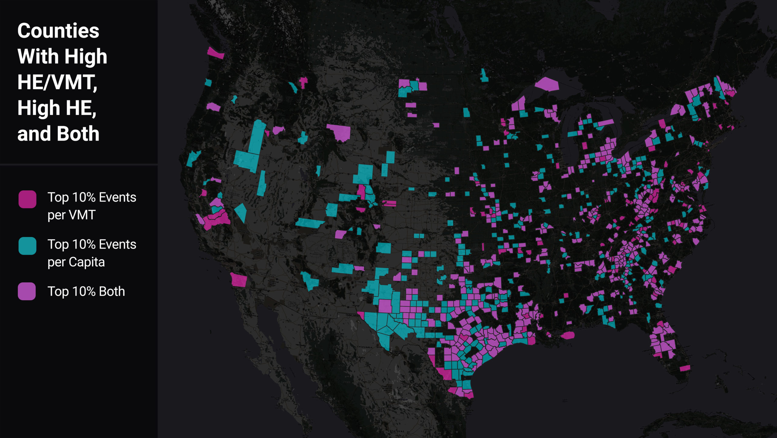
We found a majority of counties that have high HE per VMT also have high VMT per capita. However, there are 127 counties which are in the top 10% of harsh braking events per VMT and not per capita, indicating areas of especially high risk for locals. As shown in the map below, many of these counties are rural and situated along major highways. Thus these counties’ population may be bearing the safety impact of “cut through” drivers.
Figure 3: Heatmap of U.S. counties comparing those with high HE/VMT (magenta) to those with high HE per capita (aqua), and high in both categories (light purple).
Conclusion
We see here that integration of multiple data sources can better inform strategic safety planning and decision-making. Like crash and injury rates, which normalize crashes relative to the amount of travel, combining near-miss data with VMT and population data (and more) can help safety professionals proactively zero in on where crashes are most likely to happen, and implement appropriate safety measures. This approach is another data point, and another tool in the toolbox, for making progress toward zero deaths.Summarized from “Private Versus Shared, Automated Electric Vehicles for U.S. Personal Mobility: Energy Use, Greenhouse Gas Emissions, Grid Integration, and Cost Impact” by Colin J. R. Sheppard, Alan T. Jenn, Jeffery B. Greenblatt, Gordon S. Bauer, and Brian F. Gerke, Environmental Science & Technology 55, no. 5 (March 2, 2021): 3229–39.


