Jump Ahead

Big data is now a common tool for agencies, firms, and businesses looking to understand traffic conditions and transportation patterns – from analyzing the top routes taken by drivers to anticipating how a bike lane will impact safety and congestion.
Alongside this growing adoption of big transportation data, a host of data providers have also proliferated, presenting users with a complex array of options that can be challenging to navigate.
INRIX is among the commonly used big data providers with solutions aimed at transportation use cases and related land use and business applications.
INRIX Pros
INRIX is a popular choice for:
- Real-time analytics
- Safety analytics targeted at securing grant funds
- Smart Delivery analytics, including data on ride share and food delivery patterns
- Parking and curb analytics
INRIX Pricing
Like most INRIX competitors covered here, INRIX’s website does not have explicit pricing information readily available, and pricing likely varies based on the metrics and coverage needed.
So how do INRIX’s competitors and alternatives stack up, and when should you consider other options for big transportation data? Below, we explore some of INRIX’s most common alternatives, and the pros and cons of each choice.
StreetLight
Among the leading big data providers in the transportation landscape, StreetLight is the most widely adopted transportation platform in North America. Backed by a robust set of third-party validations, white papers, and customer testimonials, StreetLight is highly trusted by transportation agencies, firms, and businesses across the U.S. and Canada.
Due to StreetLight’s strong reputation and presence in the market, you may have already seen its data at work on a wide variety of use cases, from Caltrans’s work on expediting highway construction in Sacramento to proving the value of bus infrastructure investments in Vancouver.
So what makes StreetLight such a popular choice?
Diverse and Cutting-Edge Data Sources
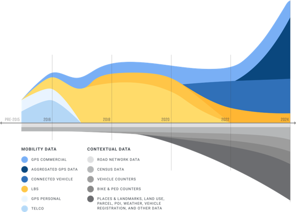
StreetLight has a long history in transportation data, and has built up a 10+ year repository of mobility patterns since its founding in 2011. As data sources have come and gone, StreetLight has continuously updated its methodologies to take advantage of emerging data sources and ensure users get only the most reliable insights based on real-world traffic patterns and ample datasets.
This allows StreetLight to turn the richest, largest, and most secure datasets available today into reliable and granular metrics used by professionals across North America.

Specialized Solutions for Many Use Cases
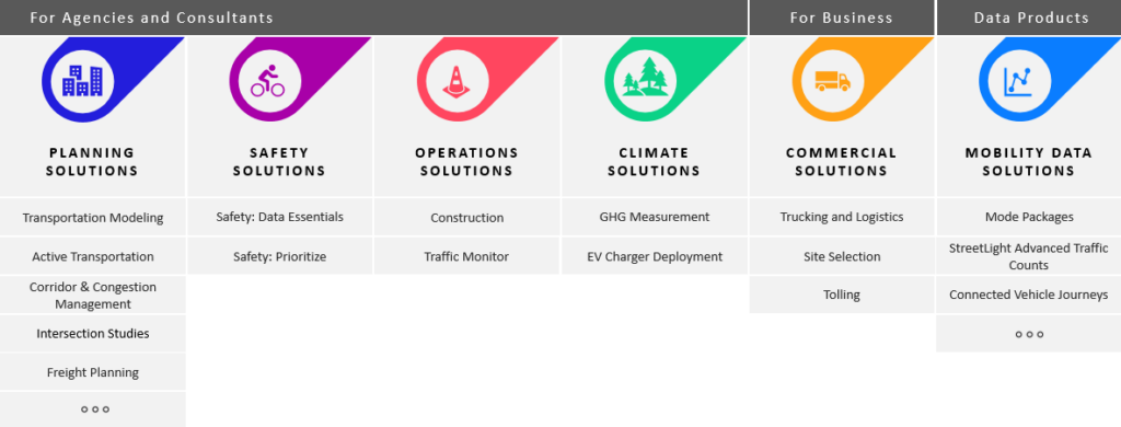
Because of its long history in the industry, StreetLight also offers the advantage of an entire suite of products that address the most common challenges faced by transportation professionals. From improving pedestrian safety and deploying EV chargers to managing traffic congestion and planning construction detours, StreetLight’s purpose-built solutions make it easy for users to make data-driven decisions about their road network, client projects, or business operations.

Highly Granular Data for any Geography in North America
Streetlight’s data also offers deep granularity across space and time. Thanks to its robust repository of data and diverse set of industry-leading data sources, users can confidently dive deeper into highly granular analyses – even looking at temporal increments as small as 15 minutes, and spatial increments as small as a single road segment. In other words, you can get data on any road, any mode, and for any time period.
That means not only can you use StreetLight to understand high-level historical trends over the past five years, but you can also monitor fast-changing traffic trends over the course of a single morning. Transportation operations experts can even monitor real-time traffic patterns that happened a few seconds ago, to ensure traffic is moving safely and efficiently. Likewise, you can zoom in on individual road segments or get region-wide insights, depending on the scope of your project.
This granularity is a major advantage for transportation modelers, who need granular data based on real, observed traffic patterns to help predict how conditions will change over time, or in response to specific infrastructural and policy changes.
Granular data is also highly valuable for practitioners at public agencies, firms, and businesses, who need actionable insights to prioritize projects, evaluate impact, and anticipate future needs.
Industry Longevity and Reliability
The transportation data landscape has undergone several evolutions since StreetLight’s founding in 2011. But StreetLight’s industry-leading data science engine has stood the test of time, offering stability and transparency to its users during times of uncertainty.
Today, StreetLight is part of Jacobs, a Fortune 500 company with years of industry knowledge, adding to StreetLight’s stability in the market.
Pros of StreetLight Over INRIX
With ample white papers and third-party validations available, StreetLight is a strong choice for users who value data transparency or need to ensure the data they use meets very specific qualifications.
For practitioners looking to analyze all modes in one platform, StreetLight offers tools for planners to access insights for vehicle, truck, bicycle, pedestrian, bus, and rail modes.
Because some of INRIX’s solutions are available on non-integrated 3rd-party platforms, users who prefer an integrated, seamless experience may choose StreetLight.
StreetLight Pricing
StreetLight’s pricing depends on which solution you choose. Custom metrics packages may also be available depending on your goals and budget.
To learn more about StreetLight’s plans and pricing, visit our Plans page.
Do you need data to inform your next project?
Get StartedReplica
Replica’s tagline is “Data to Drive Decisions about the Built Environment,” and its data offerings are designed to match. Similar to INRIX, many of Replica’s applications cater directly to transportation industry use cases, and related use cases in land use and commercial real estate.

Some of Replica’s applications include:
- Active Transportation Analysis
- EventSight
- GeoSnapshot
- Standard Growth Scenarios
- Transit Demand and Equity Scores
Replica Pros
Replica’s strengths include:
- Dashboard data visualizations
- Filtering capabilities
- Consumer spending behaviors
- Land use insights
- Traditional mobility patterns
Replica Cons
Despite Replica’s strengths, data recency and granularity may not be as strong as other options on the market. Transportation modelers or other users who want to analyze synthetic behaviors rather than empirical behaviors may also choose Replica. Users will also have less flexibility in how they use the data, since Replica does not offer API or ESRI integration. These limitations can make it challenging to analyze small time frames and individual roadways or segments.
Replica Pricing
A complete breakdown of Replica’s pricing info is not readily accessible on their website, but Replica offer a pricing breakdown for public agencies based on the population of the city, county, or state the agency serves, as well as prices for a single department vs. multiple departments within an agency.
LOCUS

LOCUS, a subsidiary of the consulting firm Cambridge Systematics, was once a visualization tool used exclusively for Cambridge Systematics clients. Now, it is a standalone, on-demand platform offering performance, safety, freight, EV, and multimodal mobility metrics. Like other INRIX alternatives, it specializes in delivering insights on transportation and travel behavior.
LOCUS is a newer offering on the market with a smaller range of products. However, they emphasize custom solutions paired with consulting services through Cambridge Systematics to help customers accomplish a variety of goals.
LOCUS Pros
One thing that makes LOCUS unique is its strengths in transit data, including:
- Real-time transit activity
- Ridership trends
- Transit performance metrics
LOCUS’s real-time transit dashboard uses farecard or survey data and routing to help customers understand these transit patterns.
LOCUS Cons
LOCUS emphasizes custom-built data solutions paired with consulting services, making it a viable option for customers who want a bespoke approach. However, LOCUS offers fewer out-of-the-box solutions than some INRIX alternatives, and may not be the best fit for those who want a do-it-all platform or a self-driven research experience.
LOCUS Pricing
LOCUS’s pricing info is not featured on their website, and may vary based on the customer’s needs.
AirSage

AirSage offers transportation data “customized” to each customer’s needs, and serves public agencies, firms, and businesses. It uses Big Data to deliver insights on how people and vehicles move.
AirSage offers a few products, including:
- Trip Matrix – an Origin-Destination matrix the includes trip attributes and trip purpose information
- Activity Density – measuring population movement and density, useful for event-based migration patterns such as emergency evacuations
- Pedestrian Activity Density – specifically for understanding pedestrian movements
- Target Location Analysis – used to understand visitor activity at points of interest
AirSage Pros
Many of AirSage’s products are delivered in CSV format, making it easy to integrate with:
- Your own dashboards
- GIS platforms
- Power BI
- Excel
- Other mapping tools
AirSage Cons
However, customers who value data transparency may choose other alternatives due to AirSage’s limited availability of white papers, 3rd-party validations, and case studies. Those who want to analyze bike, bus, rail, or truck modes may also prefer other options, as AirSage places more emphasis on personal vehicle and pedestrian use cases.
AirSage Pricing
AirSage does not offer explicit pricing info on their website, however their Terms of Service state that pricing is available on request from a Sales representative, and may vary based on usage and location.
Looking for an INRIX alternative?
While INRIX may appeal to those who need global transportation insights, or with specific interests in parking, curb, and signal data, StreetLight is a powerful alternative for practitioners across North America who value a seamless experience that allows them to analyze any mode, any road, and any time period within a single integrated platform.
If data transparency is important to you, you may also appreciate StreetLight’s robust variety of 3rd-party validations and white papers, which help make StreetLight one of the industry’s most trusted transportation data platforms, satisfying even the most highly technical users in agencies, firms, and businesses.
If these advantages appeal to you, reach out to our team to learn more about StreetLight! We’d love to hear about your goals and help determine if StreetLight is right for you.