Travel Planning for Memorial Day – The Data-Driven Way

Memorial Day has a rich history of honoring soldiers who sacrificed their lives in service to their country. However, it’s also a travel-filled holiday weekend that signals the beginning of summer for many Americans. These days, it seems like most Memorial Day conversations revolve around traffic, congestion, and busy airports. Just try searching for “Memorial Day” on Google. You’ll see that about half of the search results are about holiday-related transportation challenges.
Vacationers and planners like want to avoid traffic snarls, and StreetLight can help. Although it’s easy for individuals like me to get travel data from Google Maps, it might not be so tailored to Memorial Day travel patterns. For transportation professionals, StreetLight InSight® can provide this type of data at an extremely fine resolution and on a massive scale. The best part is that it takes just a few minutes to run most analyses and just a few hours for more complex studies.
Like the avid planner I am, there were several questions swirling around my head while thinking about this trip. How bad will the traffic be when I head to the airport? When should I leave my house so I don’t miss my flight? Luckily, I work at StreetLight Data, and I can use our StreetLight InSight platform to answer transportation questions quickly and easily. In this blog post, I’ll show you how I did it.
The StreetLight InSight Analysis
I used StreetLight InSight to analyze traffic on the Thursday to Saturday before Memorial Day last year to help predict my travel experience – and, hopefully, plan the best possible route to San Francisco International Airport (SFO). I chose to analyze Thursday-Saturday because I think those are the most popular times to go to SFO for a weekend trip. To protect my privacy, I’ve changed the parameters of my exact travel plan: Let’s pretend I live near the Financial District in San Francisco and that I am going to spend this Memorial Day in Hawai’i.


When Should I Leave for the Airport?
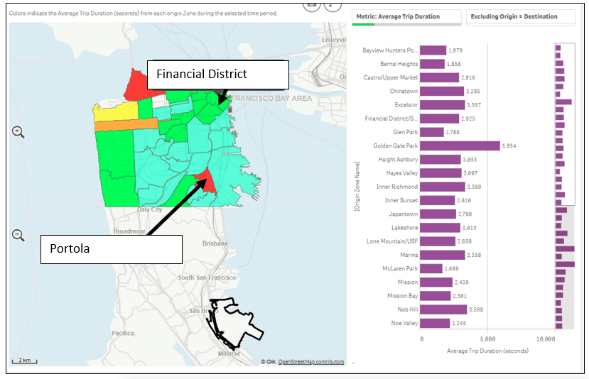
Utilizing StreetLight’s Origin-Destination Analysis, I can find the top traffic generator neighborhoods in San Francisco for trips to the airport. The majority of traffic comes from the Financial District. It’s interesting that trips coming from Financial District take half the amount of time (40 mins), of those coming from Portola, but the distance traveled is twice as long.
The visualization above shows the average duration of trips that originate in different San Francisco neighborhoods and travel to SFO.
When is the Busiest Time at the Airport?
I also used StreetLight InSight to analyze the level of activity at SFO on an hourly basis. As you can see in the chart the below, the airport will be busy all day starting from 5am, and noon is the busiest hour. That means I have to leave a little bit more of a buffer on my travel time for security and queuing at the gate.
What’s the Best Mode of Travel?
I have two primary options for getting to SFO: Taking BART, our regional light rail system, or taking a ride with a transportation network company (TNC) like Uber or Lyft. For this piece of the analysis, I will have to pull other data sources to calculate the cost vs. time trade-off.
- TNCs (data from Uber Fare Estimate): $32 – 41 (40 mins)
- BART (data from BART): $9.15 (34 mins)
**Both estimates exclude the wait time for TNCs and walk time to BART station.
BART is a lot more affordable and faster than the TNC ride, so public transit is the clear winner for my mode of travel to the airport this Memorial Day weekend.
For transportation planners, holiday and other event analyses can help choose optimal routes for peak travel times. Get ahead of the holiday or your next event with accurate data, and make sure all modes of travel run smoothly.

