Blog Post
StreetLight Competitors and Alternatives
Jump Ahead

Today, the transportation industry, smart cities, and commercial businesses are all increasingly turning to big transportation data to make informed decisions. Alongside this growing demand, big data providers have also proliferated, making decisions about where to source this data more complex.
StreetLight has long been a frontrunner in the transportation data landscape, and below we’ll explain a few reasons why it remains a popular choice. But we’ll also cover some leading alternatives to StreetLight and how they may be useful for certain use cases and practitioners so you can explore your options and find the best solution.
As you’ll see, while many of these alternatives do certain things well, StreetLight is a strong choice for granular, empirical, reliable, full-coverage metrics across North America.
If you’re a current customer looking to improve upon your experience with StreetLight, or have a project you’re not sure how to accomplish in our platform, reach out to our Support team here! Our best-in-class customer service and full suite of training and support resources are part of what makes StreetLight the leading choice in transportation data analytics.
Why People Choose StreetLight
StreetLight is the most widely adopted transportation software, trusted by transportation agencies across the U.S. and Canada, with third-party validations across North America backing its reliability across a wide range of applications. Due to its strong reputation in the transportation data landscape, you may have already seen StreetLight data at work on some high-profile projects, such as the rebuilding of the collapsed Fern Hollow Bridge, or major industry research like this report revealing VMT and congestion are higher than ever.
So what makes StreetLight such a popular choice for agencies, firms, and businesses?
Comprehensive and Cutting-Edge Data Sources
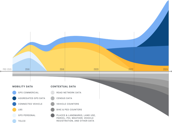
One key advantage to StreetLight is its long history in the transportation industry. Founded in 2011, StreetLight has a 10+ year repository of mobility patterns and is continuously updating its data sources as new ones emerge. This allows StreetLight to turn the richest, largest, and most secure datasets available today into reliable and granular metrics used by professionals across North America.

Purpose-Built Solutions Supporting a Wide Range of Use Cases
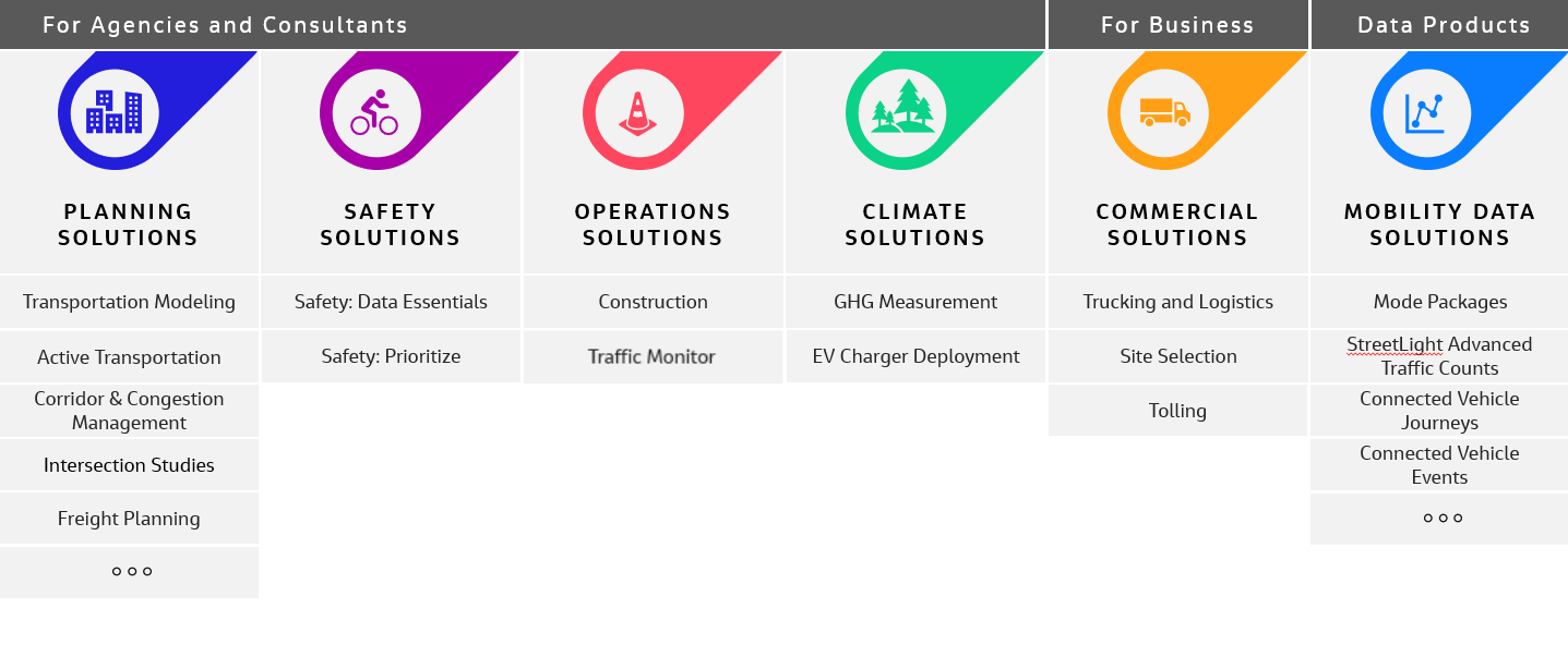
StreetLight’s long history in transportation has evolved into a robust suite of products that directly address the needs of transportation professionals. Whether you need to manage traffic congestion, improve safety, or deploy EV chargers, StreetLight has a purpose-built solution to help you make data-driven decisions impacting urban mobility and more.

Highly Granular Data for any Geography in North America
Not only can StreetLight support a wide variety of use cases, our data also offers deep granularity across space and time. In other words, you can get data on any road, any mode, and for any time period. That means you can analyze fast-changing road conditions (in increments as small as 15 minutes), high-level historical trends over the past five years, or real-time traffic patterns that happened a few seconds ago for transportation operations management. Similarly, you can zoom in on individual road segments or get region-wide insights, depending on the scope of your project.
This granularity ensures agencies of all sizes, as well as firms and businesses, can get actionable insights to prioritize projects, evaluate impact, and anticipate future needs. It’s also particularly important for transportation modeling, which requires granular, empirical data to help predict how conditions will change over time, or in response to specific infrastructural and policy changes.
Industry Longevity and Reliability
The transportation data landscape has gotten shaken up more than once since StreetLight’s founding in 2011. But as data sources come and go, StreetLight’s industry-leading data science engine has stood the test of time, offering stability and transparency to its users during times of uncertainty.
Today, StreetLight is part of Jacobs, a Fortune 500 company with years of industry knowledge, adding to StreetLight’s stability in the market.
So, given all the advantages we’ve explored, how does StreetLight compare to other mobility data providers on the market? Next, we’ll explore some of StreetLight’s competitors and alternatives to help you determine if StreetLight or another option is right for you.
Replica
Replica’s tagline is “Data to Drive Decisions about the Built Environment,” and its data offerings are designed to match. Similar to StreetLight, many of Replica’s applications cater directly to transportation industry use cases, and related use cases in land use and commercial real estate.

Some of Replica’s applications include:
- Active Transportation Analysis
- EventSight
- GeoSnapshot
- Road Closure Scenarios
- Safe Streets Planner
- Standard Growth Scenarios
- Transit Demand and Equity Scores
When People Might Choose Replica Over StreetLight
Replica is a common choice for users who want to analyze economic activity, including consumer spending trends, or certain nuanced land use scenarios.
Replica’s scenario tools (projecting population growth, employment growth, remote work rates, and other scenarios) also offer insights and data visualizations based on predicted behavior and synthetic populations.
When People Might Choose StreetLight Over Replica
StreetLight is a common choice when highly granular datasets or comprehensive, empirical coverage is needed for all road segments, intersections, or time periods. In addition, for transportation operations professionals, StreetLight data offers real-time and historical vehicle traffic patterns to solve capacity constraints and develop traffic management plans.
Transportation modelers or other users who want to analyze empirical behaviors rather than synthetic behaviors may also choose StreetLight.
With APIs and ESRI integration available, StreetLight may also be well-suited to users who want to use datasets within their own software and third-party tools.
Operations and event traffic managers may also choose StreetLight for its real-time and near real-time data solutions.
INRIX

Like StreetLight and Replica, INRIX offers big data solutions designed for transportation use cases and related land use and business applications. INRIX’s global presence also makes it a leading choice beyond North America.
Among INRIX’s strengths on the market are offerings in real-time analytics and safety analytics targeted at securing grant funds such as those available through the Bipartisan Infrastructure Law (BIL).
INRIX’s products also include Smart Delivery analytics for ride share and food delivery, as well as parking and curb analytics.
When People Might Choose INRIX Over StreetLight
INRIX’s global presence makes it a common choice for practitioners who need to analyze mobility beyond North America (however, StreetLight is beginning to expand its operations beyond North America, including the UK and other countries).
INRIX is also a strong choice for users who want to analyze parking, curb, and signal analytics, as well as real-time data that includes roadway alerts.
When People Might Choose StreetLight Over INRIX
With ample white papers and third-party validations available, StreetLight is a strong choice for users who value data transparency or need to ensure the data they use meets very specific qualifications.
For practitioners looking to analyze all modes in one platform, StreetLight offers tools for planners to access insights for vehicle, truck, bicycle, pedestrian, bus, and rail modes.
Because some of INRIX’s solutions are available on non-integrated 3rd-party platforms, users who prefer an integrated, seamless experience may choose StreetLight.
Do you need data to inform your next project?
Get StartedLOCUS

LOCUS, a subsidiary of the consulting firm Cambridge Systematics, was once a visualization tool used exclusively for Cambridge Systematics clients. Now, it is a standalone, on-demand platform offering performance, safety, freight, EV, and multimodal mobility metrics. Like other StreetLight alternatives, it specializes in delivering insights on transportation and travel behavior.
LOCUS is a newer offering on the market with a smaller range of product offerings. However, they emphasize custom solutions paired with consulting services through Cambridge Systematics to help customers accomplish a variety of goals.
When People Might Choose LOCUS Over StreetLight
Users may choose LOCUS for its transit-focused solutions, including solving for the Transit Redesign use case since you can integrate transit data (farecard and APC) with LOCUS data, providing insights on the transit travel market in your region.
When People Might Choose StreetLight Over LOCUS
StreetLight offers AADT, TMC, VMT, and other core transportation metrics not advertised on LOCUS’s website. While LOCUS users may be able to access these insights through custom solutions, users who prefer self-service access to a wide variety of industry metrics may prefer StreetLight.
In addition, for transportation operations professionals, StreetLight offers real-time and historical vehicle traffic patterns to solve capacity constraints and develop traffic management plans.
As a long-term player in the transportation data space, StreetLight also has the benefit of 10+ years of SaaS development experience, a wealth of validated white papers, dozens of case studies, and proven market stability making it a trusted choice for thousands of professionals.
CATT Lab

The Center for Advanced Transportation Technology Laboratory – AKA CATT Lab – is affiliated with the University of Maryland and offers a few products, including:
- RITIS – offering real-time data feeds, real-time situational awareness tools, and archived data analysis tools
- Probe Data Analytics Suite – a data visualization platform that uses probe data mixed with other agency transportation data to support operations, planning, analysis, research, and performance measures.
In addition to RITIS and the Probe Data Analytics Suite, CATT Lab offers several other tools for monitoring vehicle and freight traffic, including Work Zone Performance Monitoring, Virtual Weigh Station, Incident Timeline, Explore and Visualize Crashes (EVC), and Sky Graph.
CATT Lab’s strength lies in real-time data visualization tools, which are powered by “data fusion” from dozens of agency data feeds, including emergency operations centers, transportation management centers, sensors, CCTV cameras, and sub-systems across the country.
When People Might Choose CATT Lab Over StreetLight
CATT Lab’s strengths in real-time data visualization make it a good option for operations departments and practitioners within public agencies who may already have access on a non-profit or government-funded basis.
Customers looking for data visualization capabilities for air traffic control, incident analysis, or weigh stations may find additional value in CATT Lab’s unique suite of tools.
When People Might Choose StreetLight Over CATT Lab
For those who need multimodal metrics including bike and pedestrian analytics, StreetLight data may be the preferred choice, as CATT Lab’s offerings focus on vehicle and freight activity.
Additionally, some users may prefer StreetLight’s unified platform with robust onboarding, training, and support resources over CATT Lab’s various standalone tools.
Finally, while CATT Lab offers effective real-time data visualization tools, StreetLight’s repository of historical data may be better suited to certain transportation planning applications.
AirSage

AirSage offers transportation data “customized” to each customer’s needs, and serves public agencies, firms, and businesses. It used Big Data to deliver insights on how people and vehicles move.
AirSage offers a few products, including:
- Trip Matrix – an Origin-Destination matrix the includes trip attributes and trip purpose information
- Activity Density – measuring population movement and density, useful for event-based migration patterns such as emergency evacuations
- Pedestrian Activity Density – specifically for understanding pedestrian movements
- Target Location Analysis – used to understand visitor activity at points of interest
Many of AirSage’s products are delivered in CSV format, making it easy to integrate with your own dashboards, GIS platforms, Power BI, excel, and other mapping tools.
When People Might Choose AirSage Over StreetLight
According to the Airsage website, many of the offerings are primarily delivered via CSV. Users who prefer CSV data outputs may not find as much value in StreetLight’s in-platform data visualization tools and on-demand, customizable analyses, however StreetLight also offers CSV downloads for all analyses.
When People Might Choose StreetLight Over AirSage
When users are looking for a self-serve, on-demand analytics software with robust data visualization tools for historical and real-time metrics catered to their specific use case, StreetLight may be the preferred option.
StreetLight also has a wealth of 3rd-party validations, case studies, and white papers that may appeal to users that value data transparency or want to ensure their data provider meets specific technical qualifications.
How StreetLight Stacks Up Against Its Competitors
To summarize, while some StreetLight alternatives offer advantages in specific areas such as analyzing economic activity, parking and curb data, transit competitiveness, or air traffic control, StreetLight’s self-serve software with robust data visualization tools catered to the transportation industry’s top use cases makes it a popular choice for many users across North America.
With highly granular real-time and historical multimode metrics derived from diverse data sources and supported by 3rd-party validations and white papers, StreetLight is trusted by agencies, firms, and businesses to deliver reliable insights that satisfy even their most technical users.
And with the recent disruptions that have impacted the transportation data landscape, StreetLight’s unmatched market stability adds peace of mind for customers looking for a long-term solution that can fill their data gaps for years to come.
If these advantages appeal to you, reach out to our team to learn more about StreetLight! We’d love to hear about your goals and help determine if StreetLight is right for you.