How the right data-driven insights can set Safe Streets and Roads for All (SS4A) grant applications apart
See how we can helpWhat's on the page
The Value of SS4A and Safety Planning
Safety is a top concern for transportation leaders and local politicians who face pressure to reduce serious roadway crashes, which are especially common on local, non-interstate roadways, according to the NHTSA.
Now in its second round of funding, the federal government is using the Safe Streets and Roads for All (SS4A) grant program to resource regions with the funding they need to effectively develop and implement safety measures that will prevent death and serious injury on roads and streets.
What’s at stake?
Up to $5B over 5 years, between two primary grant funds:
- The Planning and Demonstration Grant for localities that don’t yet have a safety plan developed that meets federal criteria
- The Implementation Grant for localities that already have a safety plan developed and need funds to enact it
Agencies that used StreetLight in their SS4A grant applications won ˜$8M in grant funding. How did they do it? Below, we look at the expectations for each type of grant application and the relevant insights that can create the most compelling case to federal administrators.
Local buy-in is the central focus of Planning and Demonstration awards, and data can help
Planning and Demonstration Grants are intentionally a lower lift. These are grants to develop a plan.
The emphasis in these grants is on conducting outreach and creating defensible plans to justify potential impact to the public.
To that end, the grant program emphasizes:
- Data collection
- Safety and equity analysis of existing conditions
- Transparency assessment methodologies to measure improvement over time
Funding within the Planning and Demonstration Grant is particularly targeted towards community engagement.
Getting community buy-in and stakeholder engagement is challenging. The public may be skeptical of a project’s ephicacy and there are inevitably different constituencies with competing priorities. Showing grant administrators how you will use data and visualizations to make a compelling case to the public is a powerful tool for getting your grant funded.
The grant also puts an emphasis on analyzing existing conditions and historical trends to provide a baseline level of understanding of crash factors, as well as measuring progress.
StreetLight can partner with you to identify the Metrics you need in your grant application such as vehicle speed, bike volumes, and demographic traveler patterns, to create defensible plans for stakeholder buy-in and justify potential impact to the public. We can also identify the Metrics you’ll need to ensure you have no data gaps and an accurate and comprehensive view of current and historical travel activity across modes, demographics, and dayparts.
Access SS4A safety grant support
See how we can helpMake a case for an Implementation Grant using refreshed data on where infrastructure will have the most impact
Implementation Grants have a higher funding range than Planning and Demonstration Grants given their emphasis on putting infrastructure improvements into development. These grants also have a higher lift at the application stage, as planners justify the soundness and completeness of their safety plan.
Some of the called out examples of Implementation Grant improvements include:
- Low-cost roadway safety treatments
- Installing bikeways
- Installing pedestrian safety enhancements and closing network gaps
- Improving intersection safety, among many others.
Grant administrators will be looking for how applicants will prioritize critical projects, monitor and extrapolate trends, and assess impact with before-and-after studies as they determine which Implementation Grants to fund.
Transportation leaders and practitioners have a challenging task in identifying the most impactful safety projects best suited for the Implementation Grant and then making a strong case to grant administrators for how their project will significantly reduce crash-related incidents. They need to show current conditions, where the gaps are in existing infrastructure, and how they will measure the effectiveness of their projects once implemented.
Grant applicants can work with StreetLight to get support on vetting and prioritizing safety projects based on current conditions. Our data can also be used to provide future monitoring and measure effectiveness.
StreetLight can provide custom metrics around high-risk roads (Speed and Volume), infrastructure gaps (Bike and Pedestrian Volume), and equity needs (demographics tied to travel patterns). Granular metrics are critical to getting a complete view of multimodal activity and spotting safety gaps.
Zero in on the Metrics to identify the highest-priority projects and strengthen your grant application
Here are some examples of some specific questions StreetLight can help answer as you look to access your grant.
Which roadways are at high risk due to high speed traffic? Get Vehicle Speed Metrics that provide the observed speeds of vehicles on any road segment to identify high speed roadways in any community.
Where might we implement traffic calming road design changes and set appropriate speed limits for all road users? Get up-to-date Bicycle, Pedestrian and Vehicle Volume on all roadways and identify locations with high vehicle speed and high pedestrian and bike traffic.
How do we identify facilities that are opportunities for safety enhancements for pedestrians such as improved crossings, sidewalk improvements, lighting and signal improvements? Get pedestrian volume metrics to compare corridors and segments with the most pedestrian traffic which will help to develop a priority list for improvements.
Which roadways are opportunities to develop the bikeway network? Access Metrics to determine the type of bikeway separation needed based on the speed and volume of roadway traffic in your community.
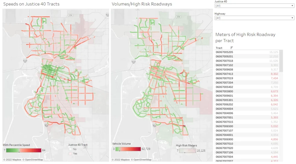
How do we take equity into consideration throughout the planning process? Identify high-risk roads in disadvantaged neighborhoods using the Justice40 criteria and layer on Metrics to see where the highest biking and walking is occurring in disadvantaged neighborhoods.
How do we measure the safety impact of infrastructure that encourages more biking and walking? Combine Bike and Pedestrian Volume Metrics with your local crash data to calculate the exposure and adjust crash risk for all modes for Before and After Studies.
But each region is unique and this list is not exhaustive. We can work together to identify the Metrics or dashboard critical to your local needs. Below is an example of a dashboard that could be used once funding is awarded and you’re ready to take the next step with your SS4A grant.

How StreetLight has already helped localities use data to develop and implement safety plans
While the Safe Streets and Roads for All grant program is new, StreetLight has been working with localities for many years on safety planning, and using data to identify and implement the highest-priority infrastructure improvements.
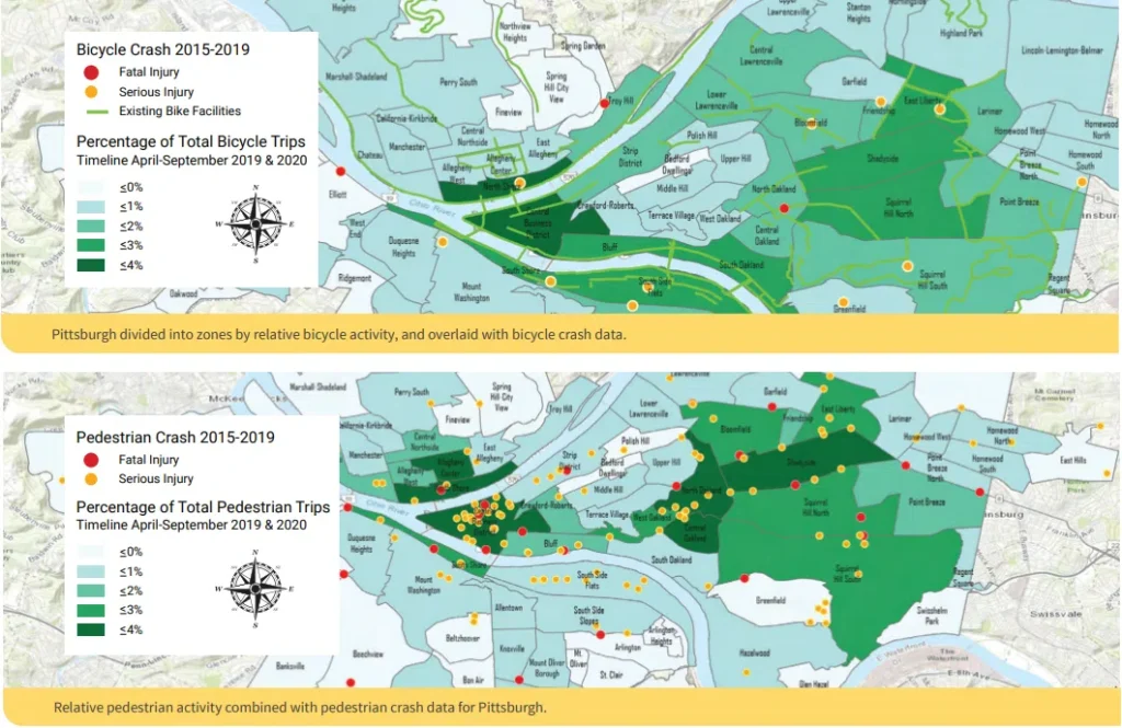
In Pittsburgh, StreetLight’s metrics on biking activity were used to contextualize the City’s crash data and help planners pinpoint the sites with the highest incidence of crashes.
What the planners found using StreetLight was counterintuitive – the most unsafe places were actually areas where less biking actually occurred.
Here’s a look at the map that the combined data allowed planners to create.

When AEC consulting firm Kittelson was tasked with creating an Active Transportation plan for Sarasota, Florida with goals of improving safety and increasing biking and walking activity, the company used StreetLight to map out top Origin-Destination pairs and subdivide those pairs using StreetLight’s analysis tools:
- Peak versus off-peak seasons
- Weekday versus weekend
- Hour of the day
- Income level
The firm prioritized areas popular for short-trip segments and identified how to bridge existing bike paths, as well as infrastructure gaps that could be filled to more closely align the existing low-stress network with the shortest path. Improved existing bike paths increase route directness allowing bikers access to safer roads.
These are just a few examples of how StreetLight can be used for safety planning. Talk to us about how we can partner with you to help you win SS4A funds and develop effective safety measures.